


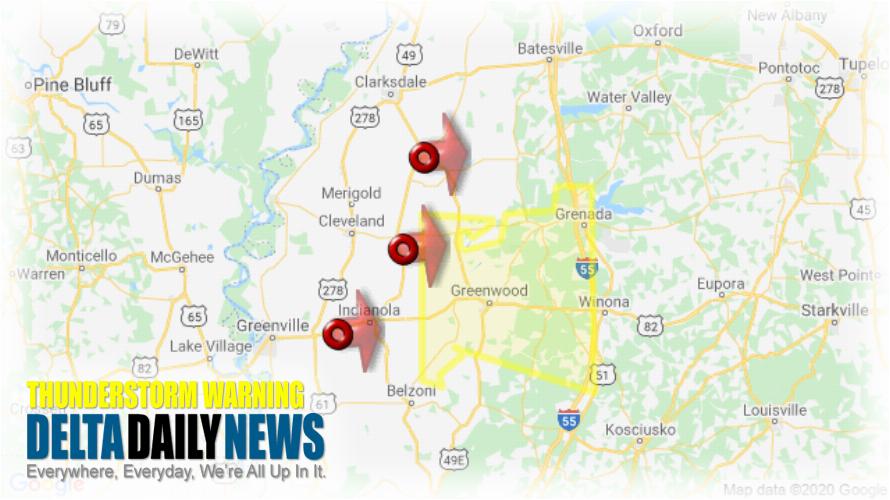
JACKSON, MS (936 PM CDT Sun Apr 12 2020) — The National Weather Service in Jackson has issued a Severe Thunderstorm Warning for Carroll County in north central Mississippi Western Grenada County in north central Mississippi Leflore County in north central Mississippi until 1030 PM CDT. At 936 PM CDT, severe thunderstorms were located along a line extending from Tutwiler to near Ruleville to Holly Ridge, moving east at 70 mph. HAZARD: 70 mph wind gusts. SOURCE: Radar indicated. Expect considerable tree damage. Damage is likely to mobile homes, roofs, and outbuildings. Severe thunderstorms will be near Sunnyside and Minter City around 945 PM CDT. Money around 950 PM CDT. Avalon around 955 PM CDT. Itta Bena, Leflore, Quito and Holcomb around 1000 PM CDT. Greenwood, Jefferson, Sidon and Bew Springs around 1005 PM CDT. Grenada and Seven Pines around 1010 PM CDT. Malmaison and Coila around 1015 PM CDT. North Carrollton around 1020 PM CDT. Other locations impacted by these severe thunderstorms include Schlater, Morgan City and Carrollton. For your protection move to an interior room on the lowest floor of a building.
[sc name=”twitterfollow”]


