


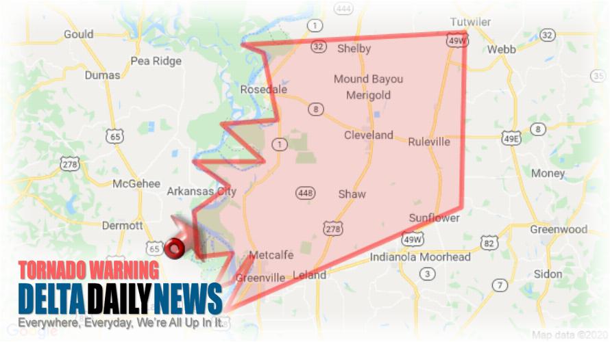
JACKSON, MS (332 AM CST Sat Jan 11 2020) — The National Weather Service in Jackson has issued a Tornado Warning for Central Sunflower County in northwestern Mississippi Northern Washington County in northwestern Mississippi Bolivar County in northwestern Mississippi until 430 AM CST. At 332 AM CST, a severe thunderstorm capable of producing a tornado was located near Mcmillan Corner, or 9 miles east of Dermott, moving northeast at 80 mph. HAZARD: Tornado. SOURCE: Radar indicated rotation. Flying debris will be dangerous to those caught without shelter. Mobile homes will be damaged or destroyed. Damage to roofs, windows, and vehicles will occur. Tree damage is likely. This dangerous storm will be near Lamont and Winterville around 340 AM CST. Scott and Benoit around 345 AM CST. Cleveland, Renova and Boyle around 400 AM CST. Mound Bayou around 405 AM CST. Drew around 410 AM CST. Parchman and Rome around 415 AM CST. Other locations impacted by this tornadic thunderstorm include Doddsville, Winstonville, Beulah, Pace and Merigold. TAKE COVER NOW! Move to a basement or an interior room on the lowest floor of a sturdy building. Avoid windows. If you are outdoors, in a mobile home, or in a vehicle, move to the closest substantial shelter and protect yourself from flying debris.
[sc name=”twitterfollow”]


