


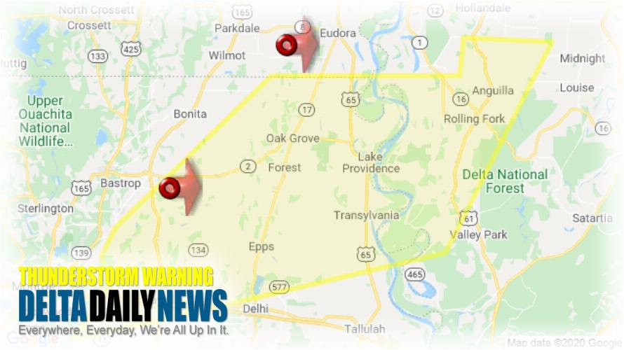
JACKSON, MS (909 PM CDT Sun Apr 12 2020) — The National Weather Service in Jackson has issued a Severe Thunderstorm Warning for Central Morehouse Parish in northeastern Louisiana East Carroll Parish in northeastern Louisiana Northwestern Madison Parish in northeastern Louisiana Northern Richland Parish in northeastern Louisiana West Carroll Parish in northeastern Louisiana Issaquena County in west central Mississippi Sharkey County in west central Mississippi until 1000 PM CDT. At 909 PM CDT, severe thunderstorms were located along a line extending from 8 miles west of Eudora to 7 miles south of Galion, moving east at 75 mph. HAZARD: 60 mph wind gusts and quarter size hail. SOURCE: Radar indicated. Hail damage to vehicles is expected. Expect wind damage to roofs, siding, and trees. Severe thunderstorms will be near Gassoway around 920 PM CDT. Oak Grove and Darnell around 925 PM CDT. Grace around 930 PM CDT. Lake Providence, Transylvania, Panther Burn and Nitta Yuma around 935 PM CDT. Delta City around 940 PM CDT. Fitler and Onward around 945 PM CDT. Other locations impacted by these severe thunderstorms include Mayersville, Pioneer, Kilbourne, Forest, Cary, Oak Ridge and Epps. For your protection move to an interior room on the lowest floor of a building.
[sc name=”twitterfollow”]


