


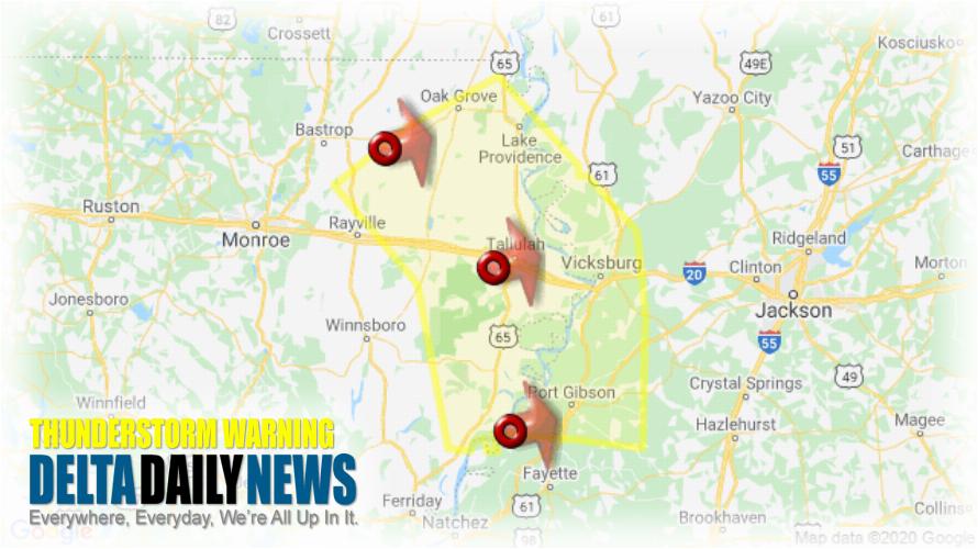
JACKSON, MS (147 PM CDT Sat May 23 2020) — The National Weather Service in Jackson has issued a Severe Thunderstorm Warning for South central Morehouse Parish in northeastern Louisiana East Carroll Parish in northeastern Louisiana Tensas Parish in northeastern Louisiana Madison Parish in northeastern Louisiana Northeastern Richland Parish in northeastern Louisiana West Carroll Parish in northeastern Louisiana Northeastern Franklin Parish in northeastern Louisiana Warren County in west central Mississippi Claiborne County in southwestern Mississippi Southwestern Issaquena County in west central Mississippi until 245 PM CDT. At 147 PM CDT, severe thunderstorms were located along a line extending from near Goodwill to near Tallulah to near St. Joseph, moving east at 35 mph. HAZARD: 60 mph wind gusts and nickel size hail. SOURCE: Radar indicated. Expect damage to roofs, siding, and trees. Severe thunderstorms will be near Alcorn around 150 PM CDT. Tallulah around 155 PM CDT. Mansford, Omega and Darnell around 200 PM CDT. Port Gibson around 210 PM CDT. Oak Grove, Eagle Bend and Pattison around 215 PM CDT. Hermanville around 225 PM CDT. Lake Providence, Redwood, Shelburn and Rocky Springs around 230 PM CDT. Other locations impacted by these severe thunderstorms include Delta, Pioneer, Mound, Forest, Oak Ridge, Richmond and Epps. For your protection move to an interior room on the lowest floor of a building.
[sc name=”twitterfollow”]


