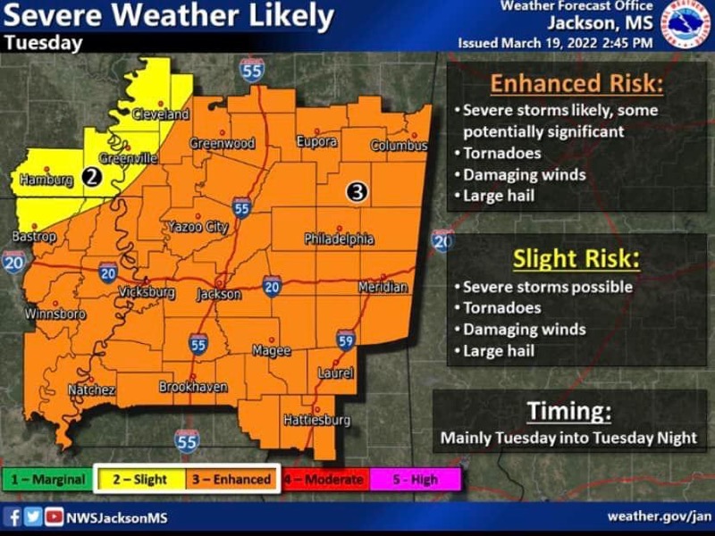
Confidence is increasing that a potentially significant severe weather episode will impact the area Tuesday into early Tuesday evening.
Some of these storms may be significant bringing a significant risk for tornadoes, large hail, and high winds.
Severe weather:
An early round of severe weather may impact locations west of the Mississippi River late Monday night into early Tuesday morning.
The main round of severe weather will be Tuesday into early Tuesday evening as storms redevelop over Louisiana and move through the area. All hazards are possible:
Tornadoes
Damaging winds
Large hail
Some of these storms may be significant.
Flash flooding:
3-5″ of rain from training thunderstorms may occur across portions of the Delta, however, confidence as to where this occurs remains too low right now to include mention in a graphic.
If confidence in placement increases, a flash flood watch may be needed.
Additional changes to the forecast are likely, including a possible upgrade to the severe weather threat.
An additional briefing may be scheduled for Tuesday morning before storms ramp up.
Stay up to date by contacting the National Weather Service Jackson office at 601-936-2189.
Stay Aware, Stay Safe NWS JAN Briefing Page


