


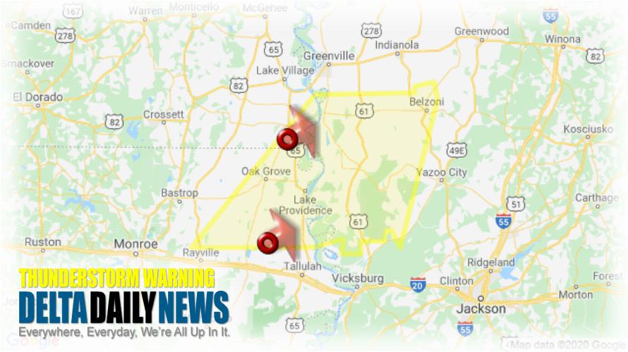
JACKSON, MS (430 AM CST Sat Jan 11 2020) — The National Weather Service in Jackson has issued a Severe Thunderstorm Warning for Southeastern Chicot County in southeastern Arkansas South central Morehouse Parish in northeastern Louisiana East Carroll Parish in northeastern Louisiana Northeastern Richland Parish in northeastern Louisiana West Carroll Parish in northeastern Louisiana Southern Washington County in northwestern Mississippi Western Yazoo County in central Mississippi Issaquena County in west central Mississippi Humphreys County in central Mississippi Sharkey County in west central Mississippi until 530 AM CST. At 430 AM CST, severe thunderstorms were located along a line extending from near Eudora to Monticello, moving northeast at 50 mph. HAZARD: 60 mph wind gusts and quarter size hail. SOURCE: Radar indicated. Hail damage to vehicles is expected. Expect wind damage to roofs, siding, and trees. Severe thunderstorms will be near Gassoway around 435 AM CST. Sondheimer around 440 AM CST. Transylvania around 445 AM CST. Avon around 450 AM CST. Fitler around 455 AM CST. Hollandale and Estill around 500 AM CST. Onward and Darlove around 505 AM CST. Isola and Holly Bluff around 520 AM CST. Other locations impacted by these severe thunderstorms include Mayersville, Silver City, Pioneer, Kilbourne, Forest, Cary, Louise and Epps. Remain alert for a possible tornado! Tornadoes can develop quickly from severe thunderstorms. If you spot a tornado go at once into the basement or small central room in a sturdy structure. For your protection move to an interior room on the lowest floor of a building.
[sc name=”twitterfollow”]


